A Thematic Tourism Map of Two Self-drive Travel Itineraries across Sicily
Keywords: Tourism Cartography, Thematic Mapping, Route Visualization, Travel Guide Design, Sicily Self-Drive Itineraries, ArcGIS Pro
Introduction
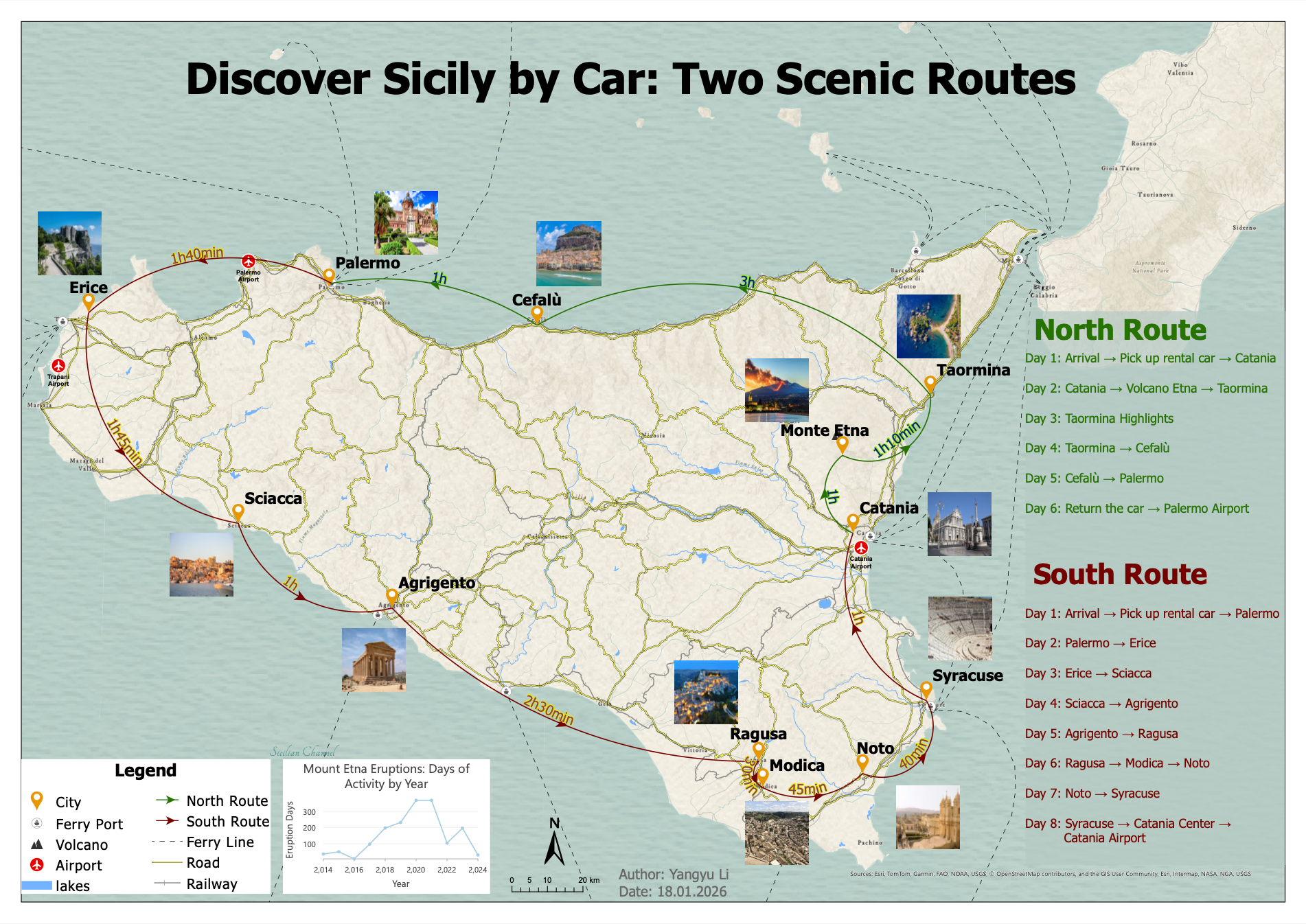
This project presents a thematic tourism map designed for visitors planning a self-drive trip across Sicily. The map visualizes two alternative travel itineraries — a Northern Route and a Southern Route — allowing users to compare different travel options and understand the spatial structure of the routes.
The project was created as part of the course Geovisualisierung und Geokommunikation and focuses on cartographic communication, thematic map design, and tourism-oriented geovisualization.
Topic and Purpose
The map is designed as a practical self-drive travel guide for Sicily, offering visitors two ready-to-use itinerary options: a Northern Route and a Southern Route.
The main purpose of the map is to help visitors plan a feasible multi-day road trip by visualizing:
-
day-by-day route sequences
-
main destinations
-
travel directions
-
approximate driving durations
-
overall spatial structure of the itineraries
The target group consists primarily of first-time visitors and independent travelers planning to rent a car and travel across Sicily.
Cartographic Design
To keep the map directly applicable for travel planning, the design intentionally avoids excessive background detail and instead emphasizes the recommended destinations and routes.
Several cartographic design decisions were applied:
-
Simplified topographic background
-
Strong visual hierarchy
-
Directional route arrows
-
Distinct route colors
-
Georeferenced labels
-
Tourism-oriented symbols
-
Integrated travel information
The North Route and South Route are clearly differentiated using colored lines and directional arrows, allowing users to quickly understand the overall travel flow.
In addition, photographs of major attractions were integrated into the layout to strengthen the tourism-oriented communication of the map.
Additional Information
The map also includes additional contextual information to support travel planning.
A small chart visualizes the number of Mount Etna eruption days between 2014 and 2024, reminding visitors that volcanic activity may occur near Mount Etna during certain periods.
Driving durations between destinations are annotated directly along the routes to provide a clearer understanding of travel times and itinerary feasibility.
Final Layout
Final thematic tourism map layout designed for Project 2 (Variant A) of the course Geovisualisierung und Geokommunikation.