The Protected Sites Area around Hintersee
Keywords: Protected Area Analysis, Buffer Analysis, Land Use Mapping, Cartographic Visualization
Introduction
This project was completed as part of the course Geographic Information Systems. The project focused on evaluating a potential expansion of the protected area around Lake Hintersee in Austria using GIS-based spatial analysis and cartographic visualization.
The workflow combined spatial analysis techniques with thematic cartographic design to assess the environmental and tourism-related impacts of a proposed 250-meter protected buffer zone around the lake.
Spatial Analysis Workflow
The analysis began by importing all required shapefiles into a file geodatabase. A 250-meter buffer zone was then generated around Lake Hintersee while excluding both the existing National Park area and the lake itself.
Several GIS processing techniques were applied during the workflow, including:
-
Buffer analysis
-
Erase operations
-
Multipart to Singlepart conversion
-
Spatial selection
-
Dissolve operations
-
Area calculations
-
Trail intersection analysis
The project also analyzed the affected land use types within the proposed protected zone and calculated their total areas in hectares.
In addition, hiking trails intersecting the new protected area were identified and their lengths were calculated to evaluate potential tourism conflicts.
Cartographic Visualization
The second part of the project focused on transforming the analysis results into a complete cartographic map layout. The final visualization includes:
-
Land use classification
-
Protected area boundaries
-
Hiking trails
-
Hillshade background
-
Statistical chart
-
Inset location map
-
Legend and map elements
Clear and meaningful colors were applied to distinguish the different land use categories and improve the readability of the map.
The final layout was designed following cartographic principles such as visual hierarchy, thematic clarity, and balanced composition.
Potential Conflicts
The analysis also considered possible conflicts related to expanding the protected area. The results indicated that some agricultural land, forest areas, and hiking trails would be affected by the new protection regulations. Balancing ecological conservation and recreational accessibility therefore becomes an important planning consideration.
Final Layout
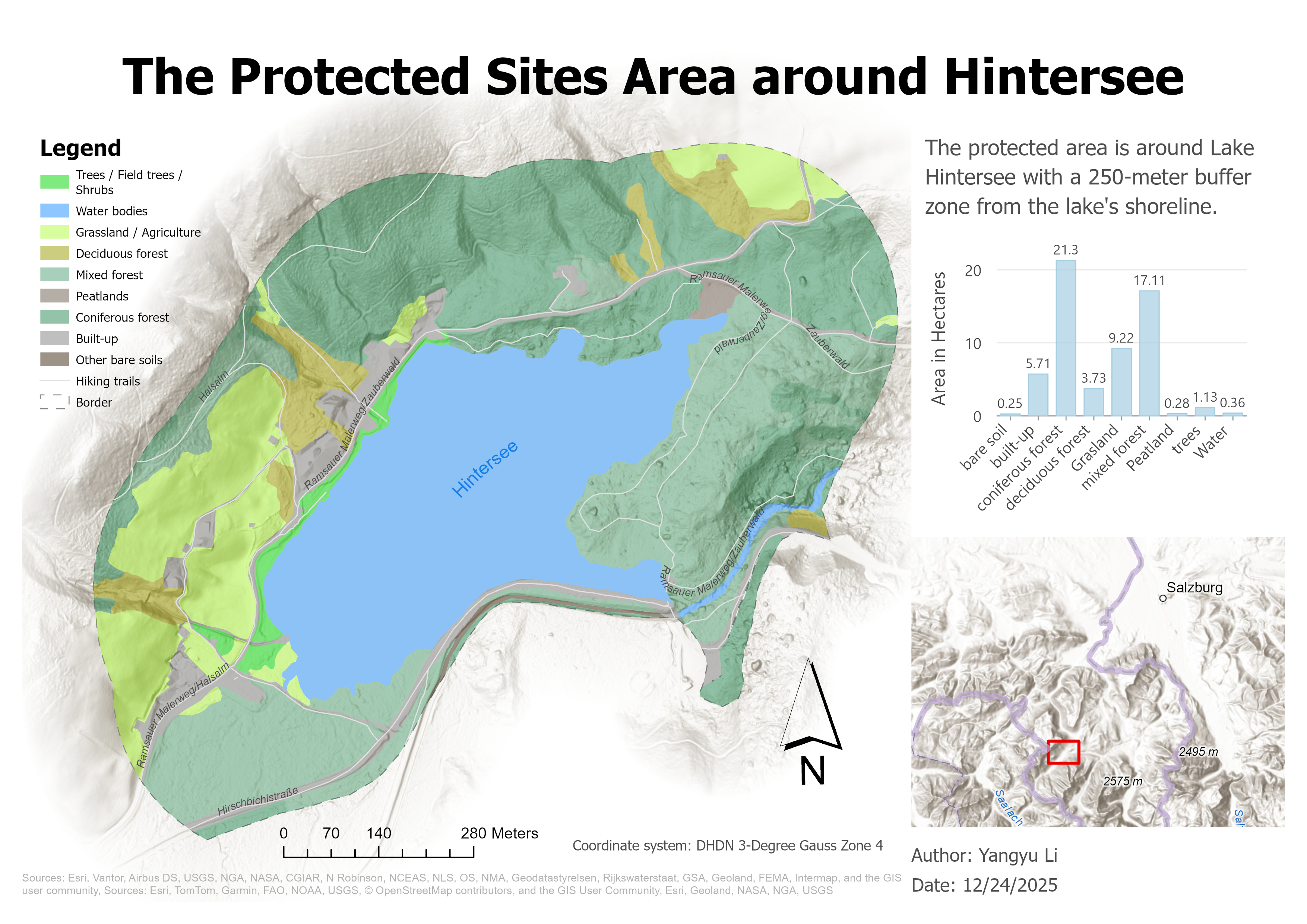
Final cartographic layout visualizing the proposed protected sites area around Lake Hintersee and the associated land use analysis.