A Spatial Database Backend for a WebGIS Application Supporting a Traditional Youshen Procession Event in Fujian, China
Keywords: Spatial Database Backend, Postgres, Spatial Analysis, QGIS
Introduction
The aim of this project is to design a spatial database backend for a WebGIS application supporting a Youshen procession event in Jianyang district, Fujian province, China.
Youshen is a traditional folk religious activity widely practiced in parts of Fujian, China. In this tradition, deities from local temples are carried in a public procession through streets and neighborhoods, often accompanied by worship activities, music, firecrackers, and large groups of residents and visitors. Youshen is not only a religious event, but also an important form of local cultural expression and community participation. It usually attracts many people and temporarily transforms ordinary urban spaces into active ceremonial and social spaces.
(Youshen is a real traditional activity in Fujian province, but this description about Youshen is generated by ChatGPT.)
The Youshen event has clear spatial characteristics. It follows a specific route through the urban environment and creates temporary concentrations of people, movement, and activity along that route. Therefore, the event may affect traffic organization, pedestrian accessibility, public service demand, and nearby residential areas.
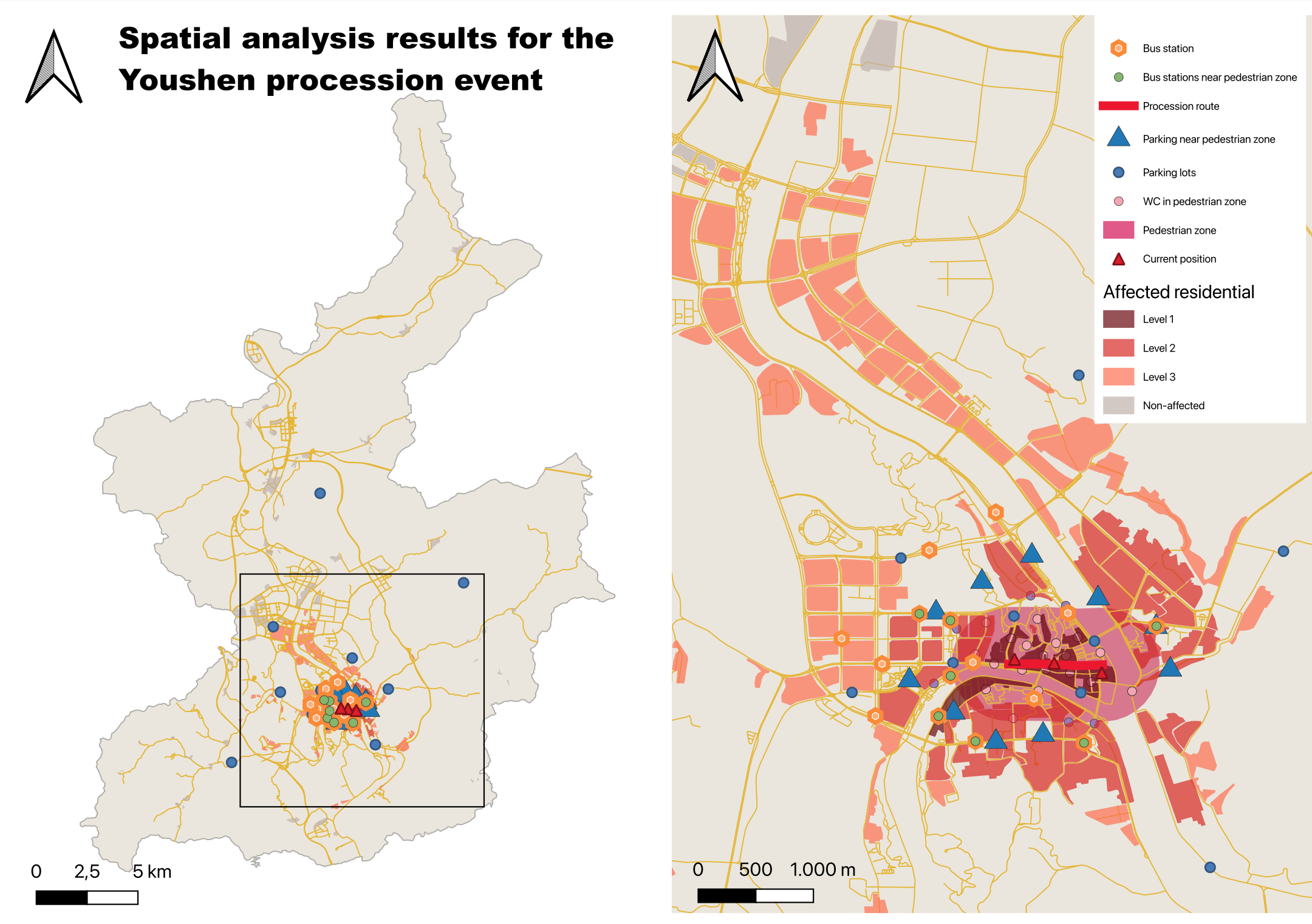
Roads along the procession route need to be fully controlled, visitors need to access the area on foot from nearby parking lots or public transport stops, and temporary service facilities such as public toilets become especially relevant. In addition, the event may generate local impacts such as increased noise exposure in surrounding residential areas.
The procession route is the key spatial element of the project. Based on this route, a pedestrian zone was created to represent the temporary event area in which normal vehicle traffic is restricted. Public toilets inside the pedestrian zone were then selected and linked to simulated visitor positions to support location-based queries. In addition, residential areas were classified according to their potential noise exposure in relation to the procession route.
Data Collection & Preparation
The data used in this project consist partly of real data and partly of manually created pseudo-data.
Context and Reference Layers
-
district (polygon): administrative boundary layer of Jianyang district used for map display
-
road (line): road network used as a reference layer for map display
Core Layers
-
procession_route (line): manually created route of the Youshen procession
-
bus_station (point): manually created bus station in Jianyang district, mainly located near the procession route
-
parking_lots (point): manually created parking locations, including parking capacity and charging availability
-
jianyang_public_wc (point): manually created public toilet locations including stall count and accessibility information
-
current_position (point): manually created sample visitor positions used to simulate real-time location queries
-
jianyang_residential (polygon): residential areas used to analyze possible noise impacts
Design
Design Logic
The procession route defines where the event takes place. From this route, the pedestrian zone is derived to represent the area where traffic restrictions apply during the event. This zone then becomes the spatial reference for identifying nearby bus stations and parking lots, as well as toilets located within the event area.
Based on the procession route and the residential data, residential features are classified into different noise impact levels according to their distance from the route. It can be used to analyze the spatial effects of the event on the surrounding built environment.
Derived Tables
Several layers in the database are derived from spatial analysis:
-
pedestrian_zone: created by buffering the procession route (1 km)
-
parking_near_pedestrian_zone: parking lots outside but close to the pedestrian zone
-
bus_station_near_pedestrian_zone: bus stations outside but close to the pedestrian zone
-
wc_in_pedestrian_zone: toilets located inside the pedestrian zone
-
nearest_wc_per_position: nearest toilet for each simulated visitor position
-
affected_residential: residential areas classified according to potential noise impact level
Query Functions
Creation of the Pedestrian Zone
The procession route layer was used as the input for defining the core event area (pedestrian zone). This zone acts as the main reference area for later queries.
Identification of Nearby Parking Lots
The parking lots layer was queried to identify parking facilities located outside the pedestrian zone but still close enough to serve visitors arriving by car.
Identification of Nearby Bus Stations
Bus stations outside the pedestrian zone but within a defined nearby distance were selected as suitable public transport access points to the event area.
Selection of Toilets Inside the Pedestrian Zone
The public WC layer was used to identify toilets located inside the event area.
Nearest Toilet for Each Visitor Position
The current position layer was used to simulate visitor locations during the event. For each position, the nearest toilet inside the pedestrian zone was identified by calculating distances between the simulated positions and the toilets.
Classification of Residential Areas by Noise Impact Level
Residential areas closest to the procession route were classified as Level 1, indicating the highest potential impact. Areas farther away were classified into Level 2, Level 3, or non-affected zones.
Final Layout